BK101
Knowledge Base
Navigation
Finding your way around. Getting from point A to point B. Spatial Intelligence.
Navigate is to direct carefully and safely. To plot the path and position of something that serves as a means of transportation. Act as the navigator in a car, plane, or vessel and plan. The act of moving something from one location to another.
Navigation is a field of study that focuses on the process of monitoring and controlling the movement of a craft or vehicle from one place to another. The field of navigation includes four general categories: land navigation, marine navigation, aeronautic navigation, and space navigation. It is also the term of art used for the specialized knowledge used by navigators to perform navigation tasks. All navigational techniques involve locating the navigator's position compared to known locations or patterns. Navigation, in a broader sense, can refer to any skill or study that involves the determination of position and direction. In this sense, navigation includes orienteering and pedestrian navigation. Latitude - Longitude.
Navigator is the member of an aircrew who is responsible for the aircraft's course. The ship's officer in charge of navigation and traveling on water as a means of transport or on a tour. The navigator's primary responsibility is to be aware of ship or aircraft position at all times. Responsibilities include planning the journey, advising the ship's captain or aircraft commander of estimated timing to destinations while en route, and ensuring hazards are avoided. The navigator is in charge of maintaining the aircraft or ship's nautical charts, nautical publications, and navigational equipment, and he/she generally has responsibility for meteorological equipment and communications. With the advent of GPS, the effort required to accurately determine one's position has decreased by orders of magnitude, so the entire field has experienced a revolutionary transition since the 1990s with traditional navigation tasks being used less frequently. Navigational Instruments.
Travel is to change location or the act of going from one place to another. A movement through space that changes the location of something. To move upon or across something. To undertake a journey or trip from place to place. A self-propelled movement.
Proceed is to move ahead and travel onward in time or space. To follow a procedure or to take a course. To resume or start again in a certain state, condition, or activity. To keep talking.
Position is a certain place or abstract location in a portion of space where something is situated.
Coordinate is a number that identifies a position relative to an axis.
Place is a point located with respect to surface features of some region.
Here is in a place now at this time. A place where the speaker is or writer is. In this circumstance or respect or on this point or detail.
Near is not far distant in time, space, degree or circumstances. Not far away in position, relationship or time. In the neighborhood of something close to something.
Close is at or within a short distance in space or time or having elements near each other. Not far away in position, relationship or time. Closed.
Direction is a line where something moves to that leads to a place or point. Frame of Reference - Wind Direction.
Relative Direction corresponds to any of the relative directions. Left and Right, Forward and Backward, Up and Down are three pairs of complementary directions, each pair orthogonal to both of the others. Relative directions are also known as egocentric coordinates.
Distance is the space between two objects or points or the size of the gap between two places, sometimes measured in time.
Distant is something located far away spatially. Being separated in space or apart in time. Far apart in relevance, relationship or kinship. Coming from or going to a distance. Stars.
Course is a general line of orientation or a line or route along which something travels or moves.
Backtracking is to retrace one's course.
Retrace is to go back over again or to reassemble something mentally.
Steering is to direct and guide a desired course and determine the direction for travelling.
Point Someone in the Right Direction is to provide someone with the necessary information that will help them to take the next step in order for them to achieve something or to locate something that they need.
Orientation is a function of the mind involving awareness of three dimensions as well as the awareness of time, place and person. Position and Momentum Space (wiki).
Orienteering is a group of sports that requires navigational skills using a map and compass to navigate from point to point in diverse and usually unfamiliar terrain, and normally moving at speed. Participants are given a topographical map, usually a specially prepared orienteering map, which they use to find control points. Originally a training exercise in land navigation for military officers, orienteering has developed many variations. Among these, the oldest and the most popular is foot orienteering. For the purposes of this article, foot orienteering serves as a point of departure for discussion of all other variations, but almost any sport that involves racing against a clock and requires navigation with a map is a type of orienteering.
US. Orienteering - Orienteering - Orienteering
Map & Compass Handbook (amazon) - Compass Map - Orienteering Book (amazon)
Environmental Awareness - Sonar
Geocaching is an outdoor recreational activity, in which participants use a Global Positioning System (GPS) receiver or mobile device and other navigational techniques to hide and seek containers, called "geocaches" or "caches", at specific locations marked by coordinates all over the world.
Geo Caching - Groundspeak - Letter Boxing
Orientation in geometry is the orientation, angular position, or attitude of an object such as a line, plane or rigid body is part of the description of how it is placed in the space it is in. Namely, it is the imaginary rotation that is needed to move the object from a reference placement to its current placement. A rotation may not be enough to reach the current placement. It may be necessary to add an imaginary translation, called the object's location (or position, or linear position). The location and orientation together fully describe how the object is placed in space. The above-mentioned imaginary rotation and translation may be thought to occur in any order, as the orientation of an object does not change when it translates, and its location does not change when it rotates. Dimensions.
Dead Reckoning is the process of calculating one's current position by using a previously determined position, or fix, and advancing that position based upon known or estimated speeds over elapsed time and course. The corresponding term in biology, used to describe the processes by which animals update their estimates of position or heading, is path integration. Drift is the angle between the heading of the airplane and the desired track. A is the last known position (fix, usually shown with a circle). B is the air position (usually shown with a plus sign). C is the DR position (usually shown with a triangle). Dead reckoning is subject to cumulative errors. Advances in navigational aids that give accurate information on position, in particular satellite navigation using the Global Positioning System, have made simple dead reckoning by humans obsolete for most purposes. However, inertial navigation systems, which provide very accurate directional information, use dead reckoning and are very widely applied. By analogy with their navigational use, the words dead reckoning are also used to mean the process of estimating the value of any variable quantity by using an earlier value and adding whatever changes have occurred in the meantime. Often, this usage implies that the changes are not known accurately. The earlier value and the changes may be measured or calculated quantities. There is speculation on the origin of the term, but no reliable information.
Wayfinding encompasses all of the ways in which people (and animals) orient themselves in physical space and navigate from place to place. The basic process of wayfinding involves four stages: Orientation is the attempt to determine one's location, in relation to objects that may be nearby and the desired destination. Route decision is the selection of a course of direction to the destination. Route monitoring is checking to make sure that the selected route is heading towards the destination. Destination recognition is when the destination is recognized.
Sense of Direction is the ability to know one's location and perform wayfinding. It is related to cognitive maps, spatial awareness, and spatial cognition. Sense of direction can be impaired by brain damage, such as in the case of topographical disorientation. Humans create spatial maps whenever they go somewhere. Neurons called place cells inside the hippocampus fire individually while a person makes their way through an environment. This was first discovered in rats, when the neurons of the hippocampus were recorded. Certain neurons fired whenever the rat was in a certain area of its environment. These neurons form a grid when they are all put together on the same plane. We get our sense of direction when we match up spatial maps we have stored in the hippocampus, to the pattern of firing neurons when we are trying to find our way back or trying to find our car in the parking lot. Dizzy.
Mental Mapping is a person's point-of-view perception of their area of interaction. Although this kind of subject matter would seem most likely to be studied by fields in the social sciences, this particular subject is most often studied by modern day geographers. They study it to determine subjective qualities from the public such as personal preference and practical uses of geography like driving directions. Mass media also have a virtually direct effect on a person's mental map of the geographical world. The perceived geographical dimensions of a foreign nation (relative to one's own nation) may often be heavily influenced by the amount of time and relative news coverage that the news media may spend covering news events from that foreign region. For instance, a person might perceive a small island to be nearly the size of a continent, merely based on the amount of news coverage that he or she is exposed to on a regular basis. In psychology, the term names the information maintained in the mind of an organism by means of which it may plan activities, select routes over previously traveled territories, etc. The rapid traversal of a familiar maze depends on this kind of mental map if scents or other markers laid down by the subject are eliminated before the maze is re-run. Mind Maps.
How our brains track where we and others go. Study suggests our brains may be more in tune with each other than we think. A new study reveals how your brain navigates places and monitors someone else in the same location. The findings suggest that our brains generate a common code to mark where other people are in relation to ourselves. Our brains create a universal signature to put ourselves in someone else's shoes. What we pay attention to may influence how our brains map out a location.
Navigating based solely on surrounding Smells. The brain can form a virtual landscape map of its surroundings based solely on smells.
Navigation using Magnetics
Migrating Mule Deer don't need Directions, study finds. Mule deer navigate in spring and fall mostly by using their knowledge of past migration routes and seasonal ranges. Big-game animals know where to migrate across hundreds of miles of vast Wyoming landscapes year after year. These animals appear to have a cognitive map of their migration routes and seasonal ranges, which helps them navigate tens to hundreds of miles between seasonal ranges.
Homing
Homing is to return home accurately from a long distance. Orienting or directing homeward or to a destination. Provide with, or send to, a home. Homing in biology is the inherent ability of an animal to navigate towards an original location through unfamiliar areas. This location may be either a home territory, or a breeding spot. Magnetoreception.
Homing Device provides direction to a target or destination.
Guidance System is a virtual or physical device, or a group of devices implementing a guidance process used for controlling the movement of a ship, aircraft, missile, rocket, satellite, or any other moving object. Guidance is the process of calculating the changes in position, velocity, attitude, and/or rotation rates of a moving object required to follow a certain trajectory and/or attitude profile based on information about the object's state of motion.
Missile Guidance refers to a variety of methods of guiding a missile or a guided bomb to its intended target.
Infrared Homing is a passive weapon guidance system which uses the infrared (IR) light emission from a target to track and follow it.
Semi-Active Radar Homing is a common type of missile guidance system, perhaps the most common type for longer-range air-to-air and surface-to-air missile systems.
Active Radar Homing is a missile guidance method in which a missile contains a radar transceiver (in contrast to semi-active radar homing, which uses only a receiver) and the electronics necessary for it to find and track its target autonomously.
Acoustic Homing is a system which uses the acoustic signature (sound) of a target to guide a moving object, such as a torpedo.
Geo-Location - Satellites - GPS
Geographic Information System is a system designed to capture, store, manipulate, analyze, manage, and present spatial or geographic data. The acronym GIS is sometimes used for geographic information science (GIScience) to refer to the academic discipline that studies geographic information systems and is a large domain within the broader academic discipline of geoinformatics. What goes beyond a GIS is a spatial data infrastructure, a concept that has no such restrictive boundaries.
 Satellite Navigation is a system that uses satellites to provide
autonomous geo-spatial positioning. It allows small electronic receivers
to determine their location (longitude, latitude, and altitude/elevation)
to high precision (within a few metres) using time signals transmitted
along a line of sight by radio from satellites. The system can be used for
providing position, navigation or for tracking the position of something
fitted with a receiver (satellite tracking). The signals also allow the
electronic receiver to calculate the current local time to high precision,
which allows time synchronisation. Satnav systems operate independently of
any telephonic or internet reception, though these technologies can
enhance the usefulness of the positioning information generated.
Satellite Navigation is a system that uses satellites to provide
autonomous geo-spatial positioning. It allows small electronic receivers
to determine their location (longitude, latitude, and altitude/elevation)
to high precision (within a few metres) using time signals transmitted
along a line of sight by radio from satellites. The system can be used for
providing position, navigation or for tracking the position of something
fitted with a receiver (satellite tracking). The signals also allow the
electronic receiver to calculate the current local time to high precision,
which allows time synchronisation. Satnav systems operate independently of
any telephonic or internet reception, though these technologies can
enhance the usefulness of the positioning information generated.
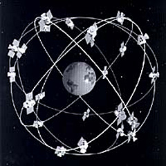
Global Positioning System is a space-based radio navigation system owned by the United States government and operated by the United States Air Force. It is a global navigation satellite system that provides geolocation and time information to a GPS receiver anywhere on or near the Earth where there is an unobstructed line of sight to four or more GPS satellites. GPS Satellite is a satellite used by the NAVSTAR Global Positioning System (GPS). The first satellite in the system, Navstar 1, was launched February 22, 1978. The GPS satellite constellation is operated by the 50th Space Wing of the United States Air Force. The GPS satellites circle the Earth at an altitude of about 20,000 km (12,427 miles) and complete two full orbits every day.
GPS Navigation Device is a device that is capable of receiving information from GPS satellites and then to calculate the device's geographical position. Using suitable software, the device may display the position on a map, and it may offer directions. The Global Positioning System (GPS) uses a global navigation satellite system (GNSS) made up of a network of a minimum of 24, but currently 30, satellites placed into orbit by the U.S. Department of Defense. GPS Apps.
Altitude is the Height above Sea Level of a location, in geography the term Elevation is often preferred for this usage. Vertical distance measurements in the "down" direction are commonly referred to as Depth. Altitude is defined based on the Context in which it is used (aviation, geometry, geographical survey, sport, atmospheric pressure, and many more). As a general definition, altitude is a distance measurement, usually in the vertical or "up" direction, between a reference datum and a point or object. The reference datum also often varies according to the context.
Real Time Kinematic positioning is a satellite navigation technique used to enhance the precision of position data derived from satellite-based positioning systems (global navigation satellite systems, GNSS) such as GPS, GLONASS, Galileo, and BeiDou. It uses measurements of the phase of the signal's carrier wave in addition to the information content of the signal, and relies on a single reference station or interpolated virtual station to provide real-time corrections, providing up to centimetre-level accuracy. With reference to GPS in particular, the system is commonly referred to as Carrier-Phase Enhancement, or CPGPS. It has applications in land survey, hydrographic survey, and in consumer unmanned aerial vehicle navigation.
Geolocation is the identification or estimation of the real-world geographic location of an object, such as a radar source, mobile phone, or Internet-connected computer terminal. In its simplest form geolocation involves the generation of a set of geographic coordinates and is closely related to the use of positioning systems, but its usefulness is enhanced by the use of these coordinates to determine a meaningful location, such as a street address. For either geolocating or positioning, the locating engine often uses radio frequency (RF) location methods, for example Time Difference Of Arrival (TDOA) for precision. TDOA systems often utilise mapping displays or other geographic information system. When a GPS signal is unavailable, geolocation applications can use information from cell towers to triangulate the approximate position, a method that is not as accurate as GPS but has greatly improved in recent years. This is in contrast to earlier radiolocation technologies, for example Direction Finding where a line of bearing to a transmitter is achieved as part of the process.
Robotic Mapping is a discipline related to cartography. The goal for an autonomous robot is to be able to construct (or use) a map (outdoor use) or floor plan (indoor use) and to localize itself and its recharging bases or beacons in it. Robotic mapping is that branch which deals with the study and application of ability to localize itself in a map / plan and sometimes to construct the map or floor plan by the autonomous robot. Evolutionarily shaped blind action may suffice to keep some animals alive. For some insects for example, the environment is not interpreted as a map, and they survive only with a triggered response. A slightly more elaborated navigation strategy dramatically enhances the capabilities of the robot. Cognitive maps enable planning capacities and use of current perceptions, memorized events, and expected consequences.
Obstacle Avoidance is the task of satisfying some control objective subject to non-intersection or non-collision position constraints, like with unmanned vehicles. Normally obstacle avoidance is considered to be distinct from path planning in that one is usually implemented as a reactive control law while the other involves the pre-computation of an obstacle-free path which a controller will then guide a robot along.
Motion Planning is a term used in Robotics for the process of breaking down a desired movement task into discrete motions that satisfy movement constraints and possibly optimize some aspect of the movement.
Simultaneous Localization and Mapping is the computational problem of constructing or updating a map of an unknown environment while simultaneously keeping track of an agent's location within it. While this initially appears to be a chicken-and-egg problem there are several Algorithms known for solving it, at least approximately, in tractable time for certain environments. Popular approximate solution methods include the particle filter, extended Kalman filter, and GraphSLAM. SLAM algorithms are tailored to the available resources, hence not aimed at perfection, but at operational compliance. Published approaches are employed in self-driving cars, unmanned aerial vehicles, autonomous underwater vehicles, planetary rovers, newer domestic robots and even inside the human body.
Precomputation is the act of performing an initial computation before run time to generate a lookup table that can be used by an algorithm to avoid repeated computation each time it is executed. Precomputation is often used in Algorithms that depend on the results of expensive computations that don't depend on the input of the algorithm. A trivial example of precomputation is the use of hardcoded mathematical constants, such as π and e, rather than computing their approximations to the necessary precision at run time. In databases, the term materialization is used to refer to storing the results of a precomputation, e.g. in a Materialized View, which is a database object that contains the results of a query. For example, it may be a local copy of data located remotely, or may be a subset of the rows and/or columns of a table or join result, or may be a summary using an aggregate function.
ZIP Code is a postal code used by the United States Postal Service (USPS) in a system it introduced in 1963. The term ZIP is an acronym for Zone Improvement Plan; it was chosen to suggest that the mail travels more efficiently and quickly (zipping along) when senders use the code in the postal address. The basic format consists of five digits. An extended ZIP+4 code was introduced in 1983 which includes the five digits of the ZIP Code, followed by a hyphen and four additional digits that reference a more specific location.
Maps
Map is a symbolic depiction emphasizing relationships between elements of some space, such as objects, regions, or themes. Many maps are static, fixed to paper or some other durable medium, while others are dynamic or interactive. Although most commonly used to depict geography, maps may represent any space, real or imagined, without regard to context or scale, such as in brain mapping, DNA mapping, or computer network topology mapping. The space being mapped may be two dimensional, such as the surface of the earth, three dimensional, such as the interior of the earth, or even more abstract spaces of any dimension, such as arise in modeling phenomena having many independent variables. Map Box - Cartography (making maps). Surveying (scale). How to Read a Map (youtube).
 Topographic Map is a type of map characterized by large-scale detail
and quantitative representation of relief, usually using contour lines,
but historically using a variety of methods. Traditional definitions
require a topographic map to show both natural and man-made features.
Topographic Map is a type of map characterized by large-scale detail
and quantitative representation of relief, usually using contour lines,
but historically using a variety of methods. Traditional definitions
require a topographic map to show both natural and man-made features.
Trail Map is a map used to aid in navigation and can symbolize an assorted amount of information of a particular area or contain only a single representation of the data it represents.
Road Map is a map that primarily displays roads and transport links rather than natural geographical information. It is a type of navigational map that commonly includes political boundaries and labels, making it also a type of political map. In addition to roads and boundaries, road maps often include points of interest, such as prominent businesses or buildings, tourism sites, parks and recreational facilities, hotels and restaurants, as well as airports and train stations. A road map may also document non-automotive transit routes, although often these are found only on transit maps.
Geologic Map is a special-purpose map made to show geological features. Rock units or geologic strata are shown by color or symbols to indicate where they are exposed at the surface. Bedding planes and structural features such as faults, folds, foliations, and lineations are shown with strike and dip or trend and plunge symbols which give these features' three-dimensional orientations.
The genius of the London Tube Map: Michael Bierut (video and text)
Topography is the study of the shape and features of the surface of the Earth and other observable astronomical objects including planets, moons, and asteroids. The topography of an area could refer to the surface shapes and features themselves, or a description (especially their depiction in maps). Topology.
Topographical Disorientation is the inability to orient oneself in one's surroundings as a result of focal brain damage. This disability may result from the inability to make use of selective spatial information (e.g., environmental landmarks) or to orient by means of specific cognitive strategies such as the ability to form a mental representation of the environment, also known as a cognitive map. It may be part of a syndrome known as visuospatial dysgnosia.
Scale of a Map is the ratio of a distance on the map to the corresponding distance on the ground. This simple concept is complicated by the curvature of the Earth's surface, which forces scale to vary across a map. Because of this variation, the concept of scale becomes meaningful in two distinct ways. The first way is the ratio of the size of the generating globe to the size of the Earth. The generating globe is a conceptual model to which the Earth is shrunk and from which the map is projected. The ratio of the Earth's size to the generating globe's size is called the nominal scale (= principal scale = representative fraction). Many maps state the nominal scale and may even display a bar scale (sometimes merely called a 'scale') to represent it. The second distinct concept of scale applies to the variation in scale across a map. It is the ratio of the mapped point's scale to the nominal scale. In this case 'scale' means the scale factor (= point scale = particular scale). If the region of the map is small enough to ignore Earth's curvature, such as in a town plan, then a single value can be used as the scale without causing measurement errors. In maps covering larger areas, or the whole Earth, the map's scale may be less useful or even useless in measuring distances. The map projection becomes critical in understanding how scale varies throughout the map. When scale varies noticeably, it can be accounted for as the scale factor. Tissot's indicatrix is often used to illustrate the variation of point scale across a map.
Linear Scale is a means of visually showing the scale of a map, nautical chart, engineering drawing, or architectural drawing. On large scale maps and charts, those covering a small area, and engineering and architectural drawings, the linear scale can be very simple, a line marked at intervals to show the distance on the earth or object which the distance on the scale represents. A person using the map can use a pair of dividers (or, less precisely, two fingers) to measure a distance by comparing it to the linear scale. The length of the line on the linear scale is equal to the distance represented on the earth multiplied by the map or chart's scale. In most projections, scale varies with latitude, so on small scale maps, covering large areas and a wide range of latitudes, the linear scale must show the scale for the range of latitudes covered by the map. One of these is shown below. Since most nautical charts are constructed using the Mercator projection whose scale varies substantially with latitude, linear scales are not used on charts with scales smaller than approximately 1/80,000. Mariners generally use the nautical mile, which, because a nautical mile is approximately equal to a minute of latitude, can be measured against the latitude scale at the sides of the chart. While linear scales are used on architectural and engineering drawings, particularly those that are drawn after the subject has been built, many such drawings do not have a linear scale and are marked "Do Not Scale Drawing" in recognition of the fact that paper size changes with environmental changes and only dimensions that are specifically shown on the drawing can be used reliably in precise manufacturing. Linear Scale is also called a bar scale, scale bar, graphic scale, or graphical scale.
Geography IQ - Geography - Geography
Smarty Pins with Google - Google Earth Explore
Geography is a field of science devoted to the study of the lands, the features, the inhabitants, and the phenomena of Earth.
Compass
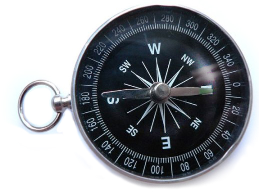 Compass is an
instrument used for navigation and orientation that shows direction
relative to the geographic cardinal directions (or points). Usually, a
diagram called a compass rose shows the directions north, south, east, and
west on the compass face as abbreviated initials. When the compass is
used, the rose can be aligned with the corresponding geographic
directions; for example, the "N" mark on the rose points northward.
Compasses often display markings for
angles in degrees in addition to (or
sometimes instead of) the rose. North corresponds to 0°, and the angles
increase clockwise, so east is 90° degrees, south is 180°, and west is
270°. These numbers allow the compass to show azimuths or bearings, which
are commonly stated in this notation.
Magnetic Pole.
Compass is an
instrument used for navigation and orientation that shows direction
relative to the geographic cardinal directions (or points). Usually, a
diagram called a compass rose shows the directions north, south, east, and
west on the compass face as abbreviated initials. When the compass is
used, the rose can be aligned with the corresponding geographic
directions; for example, the "N" mark on the rose points northward.
Compasses often display markings for
angles in degrees in addition to (or
sometimes instead of) the rose. North corresponds to 0°, and the angles
increase clockwise, so east is 90° degrees, south is 180°, and west is
270°. These numbers allow the compass to show azimuths or bearings, which
are commonly stated in this notation.
Magnetic Pole.Points of the Compass mark the divisions on a compass, which is primarily divided into four points: north, south, east, and west. These cardinal directions are further subdivided by the addition of the four intercardinal (or ordinal) directions—northeast (NE), southeast (SE), southwest (SW), and northwest (NW)—to indicate the eight principal winds. In meteorological usage, further intermediate points between cardinal and ordinal points, such as north-northeast (NNE) are added to give the 16 points of a compass rose. At the most complete division are the full thirty-two points of the mariner's compass, which adds points such as north by east (NbE) between north and north-northeast, and northeast by north (NEbN) between north-northeast and northeast. A compass point allows reference to a specific course (or azimuth) in a colloquial fashion, without having to compute or remember degrees. The European nautical tradition retained the term "one point" to describe 1⁄32 of a circle in such phrases as "two points to starboard". By the middle of the 18th century, the 32-point system was extended with half- and quarter-points to allow 128 directions to be differentiated. 32 compass points each has an angular range of 11.250 degrees where: middle azimuth is the horizontal angular direction (from north) of the given compass bearing; minimum is the lower angular limit of the compass point; and maximum is the upper angular limit of the compass point. Orienteering.
Ordinal is being or denoting a numerical order in a series. The number designating place in an ordered sequence.
Cardinal Direction are the directions north, east, south, and west, commonly denoted by their initials N, E, S, and W. East and west are perpendicular (at right angles) to north and south, with east being in the clockwise direction of rotation from north and west being directly opposite east. Points between the cardinal directions form the points of the compass. The intermediate directions (also called the intercardinal directions) are northeast (NE), southeast (SE), southwest (SW), and northwest (NW). The intermediate direction of every set of intercardinal and cardinal direction is called a secondary intercardinal direction, the eight shortest points in the compass rose that is shown to the right (e.g. NNE, ENE, and ESE). Moral Compass.
Animals use Earths Magnetism to Navigate.
Classical Compass Winds were names for the points of geographic direction and orientation, in association with the winds. Ancient wind roses typically had twelve winds and thus twelve points of orientation, sometimes reduced to eight or increased to twenty-four. Originally conceived as a branch of meteorology, the classical wind rose had only a tentative relationship with actual navigation. The Classical 12-point wind rose was eventually displaced by the modern compass rose (8-point, 16-point and 32-point), adopted by seafarers during the Middle Ages. 32-wind compass rose (wiki).
Flight Instruments are the instruments in the cockpit of an aircraft that provide the pilot with information about the flight situation of that aircraft, such as altitude, airspeed and direction. They improve safety by allowing the pilot to fly the aircraft in level flight, and make turns, without a reference outside the aircraft such as the horizon. Visual flight rules (VFR) require an airspeed indicator, an altimeter, and a compass or other suitable magnetic direction indicator. Instrument flight rules (IFR) additionally require a gyroscopic pitch-bank (artificial horizon), direction (directional gyro) and rate of turn indicator, plus a slip-skid indicator, adjustable altimeter, and a clock. Flight into Instrument meteorological conditions (IMC) require radio navigation instruments for precise takeoffs and landings.
Navigational Instrument refers to the instruments used by nautical navigators and pilots as tools of their trade. The purpose of navigation is to ascertain the present position and to determine the speed, direction etc. to arrive at the port or point of destination. History of Navigation (wiki).
Fibre Optic Gyrocompass is a compass and instrument of navigation. It is sometimes part of a ships set of compasses, which also include a conventional gyrocompass and a magnetic compass. The compass comprises a Fibre optic gyroscope sensor, which links to a computer and then locates north. This in turn links to a compass readout to provide a heading. It has very high reliability and requires little maintenance during its service life. The entire system usually includes a sensor unit, a control and display unit, and an interface and power supply unit. It is often linked with the ship's other navigational devices including GPS.
Gyrocompass is a type of non-magnetic compass which is based on a fast-spinning disc and the rotation of the Earth (or another planetary body if used elsewhere in the universe) to find geographical direction automatically. The use of a gyrocompass is one of the seven fundamental ways to determine the heading of a vehicle. Although one important component of a gyrocompass is a gyroscope, these are not the same devices; a gyrocompass is built to use the effect of gyroscopic precession, which is a distinctive aspect of the general gyroscopic effect. Gyrocompasses are widely used for navigation on ships, because they have two significant advantages over magnetic compasses: they find true north as determined by the axis of the Earth's rotation, which is different from, and navigationally more useful than, magnetic north, and they are unaffected by ferromagnetic materials, such as in a ship's steel hull, which distort the magnetic field. Aircraft commonly use gyroscopic instruments (but not a gyrocompass) for navigation and attitude monitoring; for details, see Flight instruments and Gyroscopic autopilot.
Fibre Optic Gyroscope senses changes in orientation using the Sagnac effect, thus performing the function of a mechanical gyroscope. However its principle of operation is instead based on the interference of light which has passed through a coil of optical fibre, which can be as long as 5 km.
Solar Compass is a surveying instrument that makes use of the sun's direction. Its original impetus was for use where magnetic compasses were susceptible to iron bearing minerals that made for inaccurate readings. It was then found to be superior to the magnetic compass even when local attraction was not a problem. Its close relative, a solar compass attachment to a surveyor's transit, was still a recommended method of obtaining direction in the 1973 manual of the US Bureau of Land Management. Using the location of the sun, or occasionally the moon, with astronomical tables, the solar compass enabled surveyors to run more accurate lines, saving its user valuable time. The operation is as follows: Set the sun's declination for that day, obtained by means of tables, on a scale attached perpendicular to the time dial. Set the latitude on a scale in the alidade. Set the approximate local time on a dial that rotates on a polar axis. Orient the instrument, while remaining level, so the image of the sun appears between scribed lines on a screen below a lens. The time dial is fine adjusted to bring the image between lines perpendicular to the first set. The time axis will then point to the pole. The pinnula (sighting vanes) may then be pointed to a terrestrial object and its bearing read from the angle scale. The magnetic declination may be read from a compass attached to the base plate.
Sky Polarization has been used for orientation in navigation. The Pfund sky compass was used in the 1950s when navigating near the poles of the Earth's magnetic field when neither the sun nor stars were visible (e.g., under daytime cloud or twilight). It has been suggested, controversially, that the Vikings exploited a similar device (the "sunstone") in their extensive expeditions across the North Atlantic in the 9th–11th centuries, before the arrival of the magnetic compass from Asia to Europe in the 12th century. Related to the sky compass is the "polar clock", invented by Charles Wheatstone in the late 19th century.
Pfund Telescope provides another method for achieving a fixed telescope focal point in space regardless of where the telescope line of sight is pointed. This configuration utilizes a two-axis feed flat mirror to reflect starlight into a fixed paraboloid of revolution (paraboloidal) mirror, usually with a horizontal optical axis. The paraboloid focuses through a central hole in the feed flat to a convenient distance behind the flat. No spider vanes or Newtonian secondary fold mirrors are required in this configuration. This eliminates vane diffraction and blockage, as well as secondary mirror scattering and absorption, thus improving image brightness and contrast.
Sagnac Effect is a phenomenon encountered in interferometry that is elicited by rotation. The Sagnac effect manifests itself in a setup called a ring interferometer. A beam of light is split and the two beams are made to follow the same path but in opposite directions. On return to the point of entry the two light beams are allowed to exit the ring and undergo interference. The relative phases of the two exiting beams, and thus the position of the interference fringes, are shifted according to the angular velocity of the apparatus. In other words, when the interferometer is at rest with respect to the earth, the light travels at a constant speed. However, when the interferometer system is spun, one beam of light will slow with respect to the other beam of light. This arrangement is also called a Sagnac interferometer.
Which way is North ?
How to tell which way is North using the Sun
 The Directions below are for the Northern Hemisphere.
In the Southern Hemisphere it's the Opposite (North is now South).
Sundial.
The Directions below are for the Northern Hemisphere.
In the Southern Hemisphere it's the Opposite (North is now South).
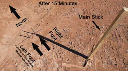
Sundial.1: Place a 3' long stick in the ground firmly.
2: Mark the end of the shadow from the 3' long stick with a smaller stick.
3: Now wait around 15 minutes.
4: Use another small stick to mark where the end of the shadow is now.
5: Lay another stick on the ground so that it touches both small sticks.
6: Place your left foot towards the first small stick marker.
7: Place your right foot towards the second small stick marker.
8: With your body facing the 2 small sticks used to mark the ends of the shadow you are now facing north. Your Right is east, your left is west and behind you is south.
Note: At 12 noon your shadow will be facing North in the Northern Hemisphere
Finding North without a compass #1 (youtube)
Another way using the Sun to tell Direction: If you have a digital watch with no hour & minute hand then just replicate a watch with sticks to match the time on your digital watch.
1: Point the hour hand at the sun.
2: Half way between the hour hand and 12 noon will be do south. (If you are in the southern Hemisphere the it would be north)
When facing north, your Right is East, your Left is West.
At Night know how to use the Stars and Moon to tell North, but of course it's always best to carry a Compass.
Find True North Without a Compass (wikihow)
Tell Time Without a Clock - Time Knowledge
Natural Navigation - Mapping Tools
Hiking and Trails Information
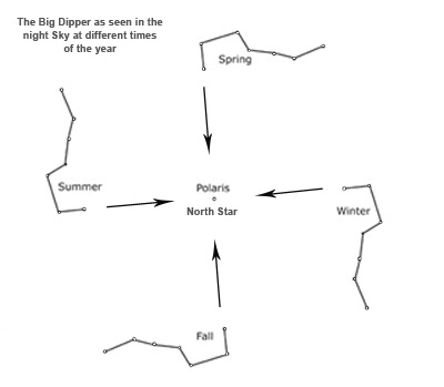
The North Star is the last star in the handle of the Little Dipper constellation. You can also find the North Star by using the Big Dipper constellation. The outermost stars of the cup of the Big Dipper forms a straight line that always "points" to the North Star or Polaris.
Star Navigation
 Celestial Navigation is the ancient science of position fixing that
enables a navigator to transition through a
space without having to rely
on estimated calculations, or dead reckoning, to know their position.
Celestial navigation uses "sights," or angular measurements taken between
a celestial body (the sun, the moon, a planet or a
star) and the visible
horizon. The sun is most commonly used, but navigators can also use the
moon, a planet, Polaris, or one of 57 other navigational stars whose
coordinates are tabulated in the nautical almanac and air almanacs.
Celestial navigation is the use of angular measurements (sights) between
celestial bodies and the visible horizon to locate one's position on the
globe, on land as well as at sea. At a given time, any celestial body is
located directly over one point on the Earth's surface. The latitude and
longitude of that point is known as the celestial body’s
geographic position (GP), the location of
which can be determined from tables in the Nautical or Air Almanac for
that year. The measured angle between the celestial body and the visible
horizon is directly related to the distance between the celestial body's
GP and the observer's position. After some computations, referred to as
sight reduction, this measurement is used to plot a
line of position (LOP) on a
navigational chart or plotting work sheet, the observer's position being
somewhere on that line. (The LOP is actually a short segment of a very
large circle on the earth which surrounds the GP of the observed celestial
body. An observer located anywhere on the circumference of this circle on
the earth, measuring the angle of the same celestial body above the
horizon at that instant of time, would observe that body to be at the same
angle above the horizon.) Sights on two celestial bodies give two such
lines on the chart, intersecting at the observer's position (actually, the
two circles would result in two points of intersection arising from sights
on two stars, but one can be discarded since it will be
far from the estimated position. Most
navigators will use sights of three to five stars, if they're available,
since that will result in only one common intersection and minimize the
chance for error. That premise is the basis for the most commonly used
method of celestial navigation, and is referred to as the
'altitude-intercept method'. There are several other methods of celestial
navigation which will also provide position finding using sextant
observations, such as the noon sight, and the more archaic lunar distance
method. Joshua Slocum used the lunar distance method during the first ever
recorded single-handed circumnavigation of the world. Unlike the
altitude-intercept method, the noon sight and lunar distance methods do
not require accurate knowledge of time. The altitude-intercept method of
celestial navigation requires that the observer know exact
Greenwich Mean Time (GMT) at the moment of
his observation of the celestial body, to the second—since every four
seconds that the time source (commonly a chronometer or in aircraft, an
accurate "hack watch") is in error, the position will be off by
approximately one nautical mile.
Dimensions (Navigating
Space) - GPS.
Celestial Navigation is the ancient science of position fixing that
enables a navigator to transition through a
space without having to rely
on estimated calculations, or dead reckoning, to know their position.
Celestial navigation uses "sights," or angular measurements taken between
a celestial body (the sun, the moon, a planet or a
star) and the visible
horizon. The sun is most commonly used, but navigators can also use the
moon, a planet, Polaris, or one of 57 other navigational stars whose
coordinates are tabulated in the nautical almanac and air almanacs.
Celestial navigation is the use of angular measurements (sights) between
celestial bodies and the visible horizon to locate one's position on the
globe, on land as well as at sea. At a given time, any celestial body is
located directly over one point on the Earth's surface. The latitude and
longitude of that point is known as the celestial body’s
geographic position (GP), the location of
which can be determined from tables in the Nautical or Air Almanac for
that year. The measured angle between the celestial body and the visible
horizon is directly related to the distance between the celestial body's
GP and the observer's position. After some computations, referred to as
sight reduction, this measurement is used to plot a
line of position (LOP) on a
navigational chart or plotting work sheet, the observer's position being
somewhere on that line. (The LOP is actually a short segment of a very
large circle on the earth which surrounds the GP of the observed celestial
body. An observer located anywhere on the circumference of this circle on
the earth, measuring the angle of the same celestial body above the
horizon at that instant of time, would observe that body to be at the same
angle above the horizon.) Sights on two celestial bodies give two such
lines on the chart, intersecting at the observer's position (actually, the
two circles would result in two points of intersection arising from sights
on two stars, but one can be discarded since it will be
far from the estimated position. Most
navigators will use sights of three to five stars, if they're available,
since that will result in only one common intersection and minimize the
chance for error. That premise is the basis for the most commonly used
method of celestial navigation, and is referred to as the
'altitude-intercept method'. There are several other methods of celestial
navigation which will also provide position finding using sextant
observations, such as the noon sight, and the more archaic lunar distance
method. Joshua Slocum used the lunar distance method during the first ever
recorded single-handed circumnavigation of the world. Unlike the
altitude-intercept method, the noon sight and lunar distance methods do
not require accurate knowledge of time. The altitude-intercept method of
celestial navigation requires that the observer know exact
Greenwich Mean Time (GMT) at the moment of
his observation of the celestial body, to the second—since every four
seconds that the time source (commonly a chronometer or in aircraft, an
accurate "hack watch") is in error, the position will be off by
approximately one nautical mile.
Dimensions (Navigating
Space) - GPS.Galactic Coordinate System is a celestial coordinate system in spherical coordinates, with the Sun as its center, the primary direction aligned with the approximate center of the Milky Way galaxy, and the fundamental plane approximately in the galactic plane. It uses the right-handed convention, meaning that coordinates are positive toward the north and toward the east in the fundamental plane.
Celestia Coordinate System is a system for specifying positions of satellites, planets, stars, galaxies, and other celestial objects. Coordinate systems can specify an object's position in three-dimensional space or plot merely its direction on a celestial sphere, if the object's distance is unknown or trivial. The coordinate systems are implemented in either spherical or rectangular coordinates. Spherical coordinates, projected on the celestial sphere, are analogous to the geographic coordinate system used on the surface of Earth. These differ in their choice of fundamental plane, which divides the celestial sphere into two equal hemispheres along a great circle. Rectangular coordinates, in appropriate units, are simply the cartesian equivalent of the spherical coordinates, with the same fundamental (x, y) plane and primary (x-axis) direction. Each coordinate system is named after its choice of fundamental plane.
Coordinate System is a system that uses one or more numbers, or coordinates, to uniquely determine the position of the points or other geometric elements on a manifold such as euclidean space. The order of the coordinates is significant, and they are sometimes identified by their position in an ordered tuple and sometimes by a letter, as in "the x-coordinate". The coordinates are taken to be real numbers in elementary mathematics, but may be complex numbers or elements of a more abstract system such as a commutative ring. The use of a coordinate system allows problems in geometry to be translated into problems about numbers and vice versa; this is the basis of analytic geometry. Spatial Intelligence.
 Latitude -
Longitude
Latitude -
LongitudeEarth rotates 15 Degrees Longitude an hour, and rotates 360 degrees every 24 hours.
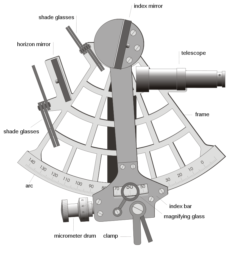
Marine Sextant (youtube)
Octant instrument is a tool used to calculate latitude at sea by measuring the angle between the sun and the horizon. It uses a small mirror to align the two celestial bodies together. The octant has an arc of 45° that measures angles of 90o.
Arc is a continuous portion of a circle. Something curved in shape. Form an arch or curve.
Marine Chronometer is a timepiece that is precise and accurate enough to be used as a portable time standard; it can therefore be used to determine longitude by means of celestial navigation.
Sailing Knowledge - "It's how you position your sails that will determine your direction."
Underwater Navigation (sound)
Nautical Chart is a graphic representation of a sea area and adjacent coastal regions. Depending on the scale of the chart, it may show depths of water and heights of land (topographic map), natural features of the seabed, details of the coastline, navigational hazards, locations of natural and human-made aids to navigation, information on tides and currents, local details of the Earth's magnetic field, and human-made structures such as harbours, buildings, and bridges. Nautical charts are essential tools for marine navigation; many countries require vessels, especially commercial ships, to carry them. Nautical charting may take the form of charts printed on paper or computerized electronic navigational charts. Recent technologies have made available paper charts which are printed "on demand" with cartographic data that has been downloaded to the commercial printing company as recently as the night before printing. With each daily download, critical data such as Local Notices to Mariners are added to the on-demand chart files so that these charts are up to date at the time of printing.
Why we see the same Stars? (star charts)
Star Position in the sky is defined by a pair of angles relative to the celestial equator: declination (d) and right ascension (a). While d is given in degrees (from +90° at the celestial north pole to -90° at the south pole), a is usually given in hours (0 ... 24h). This is due to the observation technique of star transits, which cross the field of view of telescope eyepieces because of Earth's rotation. The observation techniques are topics of positional astronomy and of astrogeodesy. Ideally the two-dimensional coordinate system a, d refers to an inertial frame of reference; the 3rd coordinate is the star distance, which is normally used as an attribute of the individual star. Star positions are changing in time, caused by precession and nutation – slow tilts of Earth's axis with rates of 50 arcseconds and 2 arcseconds respectively, per year; aberration and parallax – effects of Earth's orbit around the Sun; proper motion of the individual stars. The effects 1 and 2 are considered by so-called mean places of stars, contrary to their apparent places as seen from the moving Earth. Usually the mean places refer to a special epoch, e.g. 1950.0 or 2000.0. The 3rd effect has to be handled individually. The star positions a, d are compiled in several star catalogues of different volume and accuracy. Absolute and very precise coordinates of 1000-3000 stars are collected in Fundamental catalogues, starting with the FK (Berlin ~1890) up to the modern FK6. Relative coordinates of numerous stars are collected in catalogues like the Bonner Durchmusterung (Germany 1852-1862, 200.000 rough positions), the SAO catalogue (USA 1966, 250.000 astrometric stars) or the Hipparcos and Tycho catalogue (110.000 and 2 million stars by space astrometry). Space Travel.
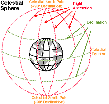 Right Ascension is the equatorial coordinate specifying the
angle,
measured eastward along the celestial equator, from the vernal equinox to
the intersection of the hour circle that passes through an object in the
sky; usually expressed in hours and minutes and seconds; used with
declination to specify positions on the celestial sphere.
Right Ascension is the equatorial coordinate specifying the
angle,
measured eastward along the celestial equator, from the vernal equinox to
the intersection of the hour circle that passes through an object in the
sky; usually expressed in hours and minutes and seconds; used with
declination to specify positions on the celestial sphere.Declination is the angular distance of a celestial body north or to the south of the celestial equator; expressed in degrees; used with right ascension to specify positions on the celestial sphere.
A minute of arc, arcminute (arcmin), arc minute, or minute arc is a unit of angular measurement equal to 1/60th of one degree.
Distance is often specified in Astronomical Units (AU)--an AU is the
average distance from the Earth to the Sun = 149,597,870 kilometers (92,955,730 miles). For objects outside the solar system, the light year (ly) is often used. This is the distance light travels in a year, One light year is equal to 63,240 AU. Rangefinder is a device that measures distance from the observer to a target.
Astronomical Unit is a unit of length, roughly the distance from Earth to the Sun. However, that distance varies as Earth orbits the Sun, from a maximum (aphelion) to a minimum (perihelion) and back again once a year. Originally conceived as the average of Earth's aphelion and perihelion, it is now defined as exactly 149597870700 metres (about 150 million kilometres, or 93 million miles). The astronomical unit is used primarily as a convenient yardstick for measuring distances within the Solar System or around other stars. However, it is also a fundamental component in the definition of another unit of astronomical length, the parsec. Astronomical System of Units is a system of measurement developed for use in astronomy.
Triangulation is the tracing and measurement of a series or network of triangles in order to determine the distances and relative positions of points spread over a territory or region, especially by measuring the length of one side of each triangle and deducing its angles and the length of the other two sides by observation from this baseline. In trigonometry and geometry, triangulation is the process of determining the location of a point by forming triangles to it from known points.
Space Triangulation is a method of establishing geodetic relationships between points on the earth’s surface by simultaneous observations of the moon, high-altitude balloons with light sources, or artificial earth satellites from these points.
X-Ray Pulsar-Based Navigation is a navigation technique whereby the periodic X-ray signals emitted from pulsars are used to determine the location of a vehicle, such as a spacecraft in deep space. A vehicle using XNAV would compare received X-ray signals with a database of known pulsar frequencies and locations. Similar to GPS, this comparison would allow the vehicle to triangulate its position accurately (±5 km). The advantage of using X-ray signals over radio waves is that X-ray telescopes can be made smaller and lighter. Experimental demonstrations have been reported in 2018. X-Ray Pulsar consists of a magnetized neutron star in orbit with a normal stellar companion and is a type of binary star system. The magnetic-field strength at the surface of the neutron star is typically about 108 Tesla, over a trillion times stronger than the strength of the magnetic field measured at the surface of the Earth (60 µT). Gas is accreted from the stellar companion and is channeled by the neutron star's magnetic field on to the magnetic poles producing two or more localized X-ray hot spots, similar to the two auroral zones on Earth, but far hotter. At these hotspots the infalling gas can reach half the speed of light before it impacts the neutron star surface. So much gravitational potential energy is released by the infalling gas, that the hotspots, which are estimated to about one square kilometer in area, can be ten thousand times, or more, as luminous than the Sun. Temperatures of millions of degrees are produced so the hotspots emit mostly X-rays. As the neutron star rotates, pulses of X-rays are observed as the hotspots move in and out of view if the magnetic axis is tilted with respect to the spin axis.
Protractor is a measuring instrument, typically made of transparent plastic or glass, for measuring angles. Most protractors measure angles in degrees (°). Radian-scale protractors measure angles in radians. Most protractors are divided into 180 equal parts. They are used for a variety of mechanical and engineering-related applications, but perhaps the most common use is in geometry lessons in schools. Some protractors are simple half-discs. More advanced protractors, such as the bevel protractor, have one or two swinging arms, which can be used to help measure the angle.
Jacob's Staff is a stick or pole with length markings to measure angles, for instance the angle between the horizon and Polaris or the sun to determine a vessel's Latitude, or the angle between the top and bottom of an object to determine the distance to said object if its height is known, or the height of the object if its distance is known, or the horizontal angle between two visible locations to determine one's point on a map. Usage: The navigator places one end of the main staff against his cheek just below his eye. He sights the horizon at the end of the lower part of the transom (or through the hole in the brass fitting) (B), adjusting the cross arm on the main arm until the sun is at the other end of the transom (C). The altitude can then be determined by reading the position of the transom on the scale on the main staff. This value was converted to an angular measurement by looking up the value in a table. In surveying, a vertical rod penetrates or sits on the ground and supports a compass or other instrument. (also called a cross-staff)
Surveying is the science of determining the terrestrial or three-dimensional positions of points and the distances and angles between them. A land surveying professional is called a land surveyor. Surveyors work with elements of geometry, trigonometry, regression analysis, physics, engineering, metrology, programming languages, and the law. They use equipment, such as total stations, robotic total stations, theodolites, which is a precision optical instrument for measuring angles between designated visible points in the horizontal and vertical planes. GNSS receivers, retroreflectors, 3D scanners, radios, clinometer, handheld tablets, digital levels, subsurface locators, drones, GIS, and surveying software.
"Men take shortcuts, while women follow well-known routes." "Sometimes the path that you're on is not the path that you chose."
